Research Centerfor Earth Operative Monitoring
| Research Centerfor Earth Operative Monitoring |
|
 |
Zenith/Electro-L Prelaunch Processing Continues at Baikonur. / January 18, 2011 /
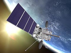
Processing of the Electro-L weather spacecraft with Zenith-2SB/Fregat-SB continues at Baikonur. Electro-L is an approved geostationary meteorological mission under development of ROSHYDROMET/PLANETA/Roskosmos, a successor spacecraft to GOMS (Geostationary Operational Meteorological Satellite), also referred to as Electro-1, launched Oct. 31, 1994 (which was never brought to full operational service due to technical problems). The overall mission objectives of Electro-L are: • To provide on an operational basis multispectral imagery (hydro-meteorological data) of the atmosphere (including the cloud-covered sky) and of the Earth’s surface within the coverage region (visible disk) of the spacecraft • To collect heliospheric, ionospheric, and magnetospheric data • To provide the needed communication services for the transmission/exchange of all data with the ground segment • To provide the services of data collection for the DCPs (Data Collection Platforms) in the ground segment as well as to provide the services of COSPAS/SARSAT. Spacecraft: The Electro-L spacecraft is being designed and built by NPO Lavochkin Research and Production Association of Moscow. The spacecraft is three-axis stabilized. A pointing accuracy of < 0.05o is provided; the angular drift is < 5 x 10⁻⁴o /s. A deployable solar array provides a power of 1.7 kW (EOL, the mean power consumption of the S/C is about 700 W). The total mass of the spacecraft is about 1620 kg (payload mass of 435 kg). The S/C design life is 10 years. Launch: A launch of Electro-L is planned for the fall 2009 on a Zenit-2 launch vehicle with a Fregat-SB booster from Baikonur, Kazakhstan. Orbit: Geostationary orbit at the nominal location of 76º East (in the equatorial plane over the Indian Ocean). OREC (Onboard Radio Engineering Complex). The objectives of the RF communication system are to provide all data transmission, relay, and retransmission services with the ground segment. These consist of the following functions: • The sensor data downlink to CPPI (Ground Acquisition and Distribution Center) is in X-band (7.5 GHz) at a data rate of 2.56-15.36 Mbit/s • Data reception from ground segment DCPs at 400 MHz (UHF), or DCP data relayed via LEO satellites at a frequency of 470 MHz. This data is transmitted from Electro-L to the CPPI in S-band at 1.7 GHz. • Onboard reception of processed hydro-meteorological data products in X-band (8.2 GHz) and relay of this data in HRIT LRIT and WEFAX formats (in S-band at 1.7 GHz) to all customers • Exchange of hydro-meteorological data and remote sensing data between regional centers in X-band (at 8.2 and 7.5 GHz) with data rates of up to 15.36 Mbit/s • Data reception of COSPAS-S&RSAT messages at 406 MHz and retransmission of these messages at 1.54 GHz. |
|||||||
|
||||||||
© Official Site of Research Center for Earth Operative Monitoring (NTS OMZ). Where any materials on this site are republished or copied, the source of the material must be identified. | |||
|
127490, Moscow, Decabristov st., b.51, h.25
|
|
||