Research Centerfor Earth Operative Monitoring
| Research Centerfor Earth Operative Monitoring |
|
 |
main page
On the geophysical environment in Japan. / October 11, 2011 /
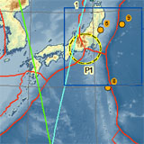
Ground-space monitoring of the signs of preparing a massive earthquake in Japan and analysis of the data are alarming in NTs OMZ experts and colleagues from the Centre «Prognoz» Tula State University. Some elements of the geophysical conditions and findings are presented on a map (Appendix 1). Cloud seismotectonic indicators and earthquakes occurring signal the activation of the Philippine plate and in the most earthquake-prone zones P1, 2,3. Note on seismic hazard map, drawn by Japanese and foreign geophysicists for 30 years, P1.1 zone is designated as potentially dangerous to the magnitude of the M6,7-7, 2, and the probability of 70%. In the forecast Doctor phis. and math Lyubushin Alexey specified area also is listed as extremely hazardous. As part of Phase 2 of the experiment (communication of 5.10.2011) revealed an interesting relationship between the parameters Synchronization of microseisms A. Lyubushin and cloud dynamics seismotectonic indicators (Appendix 1). This factor has a predictive component at the operational level.
|
|||||||
|
||||||||
© Official Site of Research Center for Earth Operative Monitoring (NTS OMZ). Where any materials on this site are republished or copied, the source of the material must be identified. | |||
|
127490, Moscow, Decabristov st., b.51, h.25
|
|
||